Cristobal strengthens, heads toward the US
Tropical storm and storm surge warnings have been issued by the National Hurricane Center for parts of the US Gulf Coast in anticipation of Tropical Storm Cristobal approaching later this weekend.
The storm, the third named system of an already active hurricane season, had maximum sustained winds of 40 mph on Friday evening.
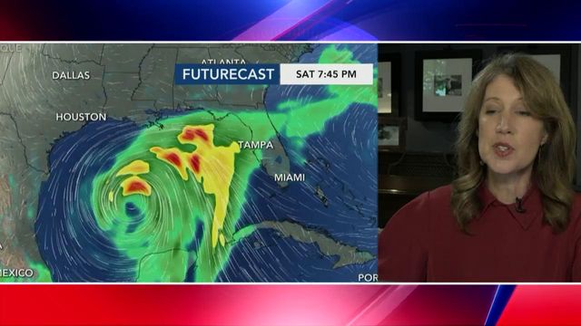
Cristobal threatens to make landfall along the Louisiana coast this weekend.
The latest forecast track has Cristobal moving ashore across the Gulf Coast as soon as Sunday afternoon.
Tropical-storm-force winds are expected to reach the US Gulf Coast between Texas and Florida as early as Saturday night, according to NHC forecasts. The storm's strength and where it might hit are likely to become clearer by Saturday morning.
"The highest winds, greatest storm surge and heaviest rain may occur east of where Cristobal makes landfall, so not only is the Louisiana coast at risk but also Mississippi, Alabama and well into the Florida Panhandle," CNN meteorologist Dave Hennen said.
"It looks like flooding will be the greatest threat from the storm and could occur over a wide area from Texas to Florida," he added. "It could produce widespread heavy rain associated directly from the storm and from a lot of tropical moisture that is already funneling into places like Florida."
As of 5 p.m. ET Friday, Cristobal was headed north as it begins to move off Mexico's Yucatan Peninsula.
A tropical storm warning has been issued for the northern Gulf of Mexico coast from east of Morgan City, Louisiana, to the Okaloosa/Walton County Florida line. A warning means that tropical storm conditions, including strong winds and heavy rainfall, are expected somewhere within the warning area within the next 36 hours.
A storm surge warning has been issued from the mouth of the Mississippi River to Ocean Springs Mississippi, including Lake Borgne. A storm surge warning means there is a danger of life-threatening inundation from rising water moving inland from the coastline during the next 36 hours, according to the hurricane center.
A tropical storm watch is in effect from Intracoastal City, Louisiana, to Morgan City. A watch means that tropical storm conditions, including strong winds and heavy rainfall, are possible within the watch area, generally within 48 hours.
A storm surge watch is in effect for Indian Pass to Aripeka, Florida, and from east of Morgan City, to the mouth of the Mississippi River. A watch means there is a possibility of life-threatening inundation, from rising water moving inland from the coastline, in the indicated locations during the next 48 hours, according to the weather service.
Gulf Coast on alert
The town of Grand Isle, Louisiana, has issued a mandatory evacuation order starting Saturday at 6 a.m., according to Grand Isle Mayor David Camardelle. The mayor said the area is expecting 2 to 4 feet of storm surge and between 6 and 10 inches of rain from the storm.
Grand Isle is located about 50 miles southeast of New Orleans.
In New Orleans, Mayor LaToya Cantrell said that the city could see 10 inches or more of rain due to the storm.
"Now is the time to start paying attention and getting ourselves ready," Cantrell said.
The city's Homeland Security Director Collin Arnold said the city's Emergency Operations Center, which has been active for three months due to the pandemic, is switching to storm mode.
Louisiana Gov. John Bel Edwards said Friday that he will ask President Donald Trump to grant a pre-landfall federal emergency declaration.
Edwards said that parts of Louisiana need to be ready for as many as 10 to 15 inches of rain this weekend as well as wind gusts as high as 60 miles per hour.
The governor urged people who plan to attends protests over the weekend to be "cognizant" of the weather forecast and Covid-19, and to take precautions to protect themselves.
Flood risk would drop if storm speeds up
Cristobal had weakened into a tropical depression but gradually regained strength back to become a tropical storm.
"If the center can maintain some structure, then it will allow the storm to quickly strengthen once it reemerges into the Gulf of Mexico this weekend," CNN meteorologist Brandon Miller said earlier on Friday.
A storm that's more intact will have a better chance of intensifying, or maintaining its strength, than a weak and ragged one.
But even then, more factors play into the intensity.
"There appears to be some limiting factors in advance of the storm to keep it from intensifying into a hurricane, with wind shear and expected dry air that the storm will entrain," Hennen said, explaining why he's skeptical the storm will strengthen significantly.
If the storm picks up speed and doesn't linger along the US coast, the flooding risk will drop.
Cristobal already has produced deadly flooding in Mexico. Portions of Mexico, Guatemala and El Salvador could get another 10 to 15 inches of rain through Friday, bringing the rain total since Saturday to near 35 inches.
The rainfall will continue to bring dangerous flash flooding and mudslides to the region. As the storm pulls away from the Mexican coast, the rain will subside.
Cristobal's impact on NC
WRAL meteorologist Elizabeth Gardner said the system has had a significant effect on Mexico and the Yucatan Peninsula -- Cristobal is dumping rain there day after day without really moving. But once Cristobal comes to the US, we aren't going to feel the same effects.
"As it moves across the coast, it's going to gain energy," Garnder said.
The system is expected to land on the Louisiana coast then move straight up and almost hit Canada.
But the impacts overall on North Carolina are expected to be minimal. North Carolina might see some rain later into next week after the storm comes back down from Canada, but it won't be anything too extreme.


